Section 2: NY-NJ State Line to Nyack
Quick Facts
Distance: 10.35 miles
Parks: Tallman Mountain State Park, Clausland Mountain County Park, Tackamack Town Park, Blauvelt State Park, Sean Hunter Ryan Memorial Park
Maps: Interactive Map, Hudson Palisades Trails (map 109)
Print-Friendly Version: Link
General Description
After following the Palisades through New Jersey, the Long Path continues into New York along the Palisades Escarpment. This section is a mix of state, county and town parks and some suburban road walking. The trail begins along US Route 9W in the hamlet of Palisades, continues to Tallman Mountain State Park, descends to the Village of Piermont, ascends to Mt. Nebo, Clausland Mountain Park, Tackamack Town Park, Blauvelt State Park, and Sean Hunter Ryan Memorial Park, and finally descends into Central Nyack. This section is rich in history, with the trail passing close to historic places such as Sneden's Landing, the Revolutionary War hamlet of Palisades, Rockland Cemetery (General Frémont's Grave) and the abandoned rifle ranges in Blauvelt State Park.
Access
Take the Palisades Interstate Parkway to Exit 4, just south of the New York-New Jersey state line. Turn north onto Route 9W and continue to the entrance of the Lamont Campus of Columbia University. By public transportation: The Red and Tan Lines buses 9W and 9A along Route 9W give access to many points along the trail.
Parking
0.00 State Line Lookout (40.98888°, -73.90662°), about one mile south of the state line.
1.00 Route 9W at Rockland County bike trail near the south entrance to Tallman Mountain State Park. (41.01546°, -73.91340°)
2.60 Tallman Mountain State Park main parking area off Rockland Road (fee in season). (41.02911°, -73.91651°)
3.45 Street parking in Piermont. (Unlocated)
6.70 Tackamack Park on Clausland Mountain Road. (41.06229°, -73.93952°)
10.35 Street parking in Central Nyack. (Unlocated)
Trail Description
0.00 The Long Path passes the entrance to Columbia University's Lamont Campus. The campus has departments for research on climatology, geochemistry, oceanography, and seismology. In another 300 feet, it turns left. Soon, the trail turns right and then stays close to Route 9W, passing a swamp on the right. The trail crosses a stone wall and ascends over a small knoll.
0.25 Turn right onto a woods road and continue downhill, roughly paralleling Route 9W.
0.45 The Long Path reaches the parking lot of a building, the former Tree Ring Lab of the Lamont-Doherty Earth Observatory, but now a daycare facility. Turn left toward Route 9W and then right onto the highway. Hikers should exercise extreme caution along this road. It has frequent high-speed traffic. Keep to the left of the road, well within the white line of the shoulder.
0.55 Reach an intersection with Washington Spring Road and Oak Tree Road in the hamlet of Palisades, New York. This is an area rich with history. To the right is Sneden's Landing. Today, it is a well-known enclave for artists and actors escaping from New York City. Historically, Sneden's Landing was the site of ferry service to Dobbs Ferry. About two miles west on Oak Tree Road are historic sites such as the De Wint House in the hamlet of Tappan, Washington's Revolutionary War headquarters, and the 1776 House, where the British spy Major André was kept prisoner prior to his execution. The Long Path continues north along Route 9W.
1.00 The Long Path turns right, leaving Route 9W, and enters Tallman Mountain State Park, passing a parking area on the left. It heads towards the river on a gravel road, part of the Tallman Bike Path.
1.30 With ruins of a brick-and-concrete building visible to the right, the Long Path turns left and continues along a raised berm. These elevated mounds of dirt were built in the early 20th century to retain seepage from a never-constructed oil storage facility that was to be established in the area. The Long Path crosses a marshy section on plank bridging and passes a pond on the right.
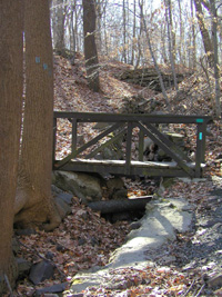
Bridge on the footpath, Tallman Mountain State Park. 2001 [TODD SCHREIBMAN]
1.95 The Long Path curves to the right and crosses the Tallman Bike Path. The Long Path then turns left and follows the Palisades Escarpment parallel to the river. There are views through the trees of Sparkill Marsh, filled with Phragmites communis (common name "giant reed") extending out into the river.
2.45 The Long Path skirts the South Picnic Area of the park, passing a stone comfort station on the left. It descends stone steps and a paved path to cross a wooden bridge over a stream. With the park swimming pool visible below to the right, the Long Path turns sharply left and goes up a paved path with a wooden railing.
2.70 At a traffic circle, the Long Path crosses the park road leading down to the river. On the other side of the road, it ascends railroad-tie steps and continues to climb, steeply at times, to the North Picnic Area. At the top, it turns right and follows the park road that runs close to the edge of the escarpment.
3.00 The Long Path reaches an outstanding viewpoint on the right, looking over the Hudson River. The Tappan Zee Bridge and Hook Mountain are visible to the north. Directly below are the mile-long Piermont Pier (the original terminus of the Erie Railroad) and the extensive Sparkill Marsh. The villages of Irvington and Dobbs Ferry may be seen across the river, with the gothic tower of the Lyndhurst mansion on the skyline to the northeast. Turn right, leave the road, and begin a steep, rocky descent towards Piermont. Interesting restaurants and shops are found in the village.
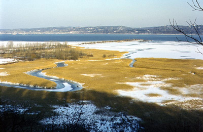
Winter view of the Sparkill Marsh. 2001 [JAKOB FRANKE]
3.15 At the bottom of the descent, the Long Path turns left on a gravel road, the route of the Tallman Bike Path. In 200 feet, the bike path ends, and the Long Path turns right on Ferdon Avenue. It immediately crosses Sparkill Creek and enters the Village of Piermont. At a traffic light, the trail crosses South Piermont Avenue (left) and Paradise Avenue (right) to continue straight ahead on Piermont Avenue.
3.45 At the old railroad crossing in the center of Piermont, the trail turns left onto Tate Avenue, climbs uphill, then turns right and parallels the river. The trail veers left and climbs up an old concrete staircase, emerging onto Ash Street adjacent to the former railroad station. (The station building, which is over 100 years old, is now unused.) The abandoned Erie Railroad right-of-way that crosses the Long Path here is a rail-trail and an official side trail to the Long Path. It provides an interesting alternative path, with Hudson River views, north to Nyack. The Long Path turns left and continues west along Ash Street to Piermont Place. Turn left on Piermont Place and then right on Crescent Road. At the end of Crescent Road turn left, and follow the path past several houses on the right. Turn right on an old fire road and, in 75 yards, reach US Route 9W. Turn right on Route 9W and follow it for a few yards to Castle Road, a rural road.
3.90 Turn left on Castle Road, which bends north. This part of the road is private. Before reaching the last house, the trail heads to the right into the woods and rejoins the old fire road. Turn right and follow this road into Rockland Cemetery. It has fine views west toward the Ramapos in the distance. About 500 feet after passing the last house, the path meets a paved cemetery road. The trail makes a 180-degree turn and continues uphill on the cemetery road to reach the top of the Palisades and a seasonal view of the Hudson. At the top, the trail passes the obelisk memorializing Henry Honeychurch Gorringe, who transported Cleopatra's Needle from Egypt, as well as the monument to General John Charles Frémont, better known as the "Pathfinder." Also buried at the cemetery, almost within touching distance of the Long Path, is George Zoebelein, a long-time trail supervisor of the Long Path in Rockland County, and a former president of the Trail Conference. George's gravesite is approximately 30 feet from where the trail makes the 180-degree turn.
4.80 The Long Path leaves the cemetery and gradually regains the Palisades ridge, where it heads northwest along the ridge. It continues on a level path through the woods, crossing several stone walls and intermittent streams.
5.50 The Long Path arrives at a three-way trail intersection. An orange-marked trail, built and maintained by Rockland County, goes to the right to Mt. Nebo, once an Air Force Nike missile site and now a recreation area for the Town of Orangetown. This trail rejoins the Long Path in 0.4 mile. The Long Path continues straight ahead and heads downhill, crosses a streambed, makes a left jog, and then goes right. An old woods road goes left and leads to NY Route 303, near the Kings Highway intersection. The trail ascends gradually and then undulates through the woods of Clausland Mountain Park, a Rockland County park.
5.90 The orange-marked trail comes in from the right. The Long Path continues, crossing several streams along the way, the last time on a wooden bridge.
6.70 The trail crosses Clausland Mountain Road and enters Tackamack Town Park in the Town of Orangetown. Tackamack was the Indian name of Jan Claus, a trader who lived in the area.*The trail passes through a metal gate and descends, first on a gravel road and then on a woods road, until it reaches a small water impoundment. Here the Long Path goes right into the woods, following the water impoundment. The trail follows the stream for a while and finally crosses it on a wooden bridge.
7.20 The Long Path crosses a road (Marsico Court) and enters Blauvelt State Park. The trail passes through a stand of evergreens and veers right, after which it joins a woods road. A nearby embankment was the site of the firing line for the pre-World War I National Guard Camp Bluefield's rifle range. They were forced to close the camp because the lead from the bullets kept landing in Grand View, to the east along the river. All the trees in this section were planted after the National Guard abandoned the rifle range. The trail continues on a series of woods roads, then parallels a target wall of the rifle range.
7.75 The Long Path climbs over a small embankment and descends a set of wooden steps to a woods road. This embankment is actually the earth-covered concrete tunnel that provided safe passage from the firing line to the target wall. The entrance to the tunnel is on the right. The trail crosses the woods road, in about 100 yards turns right onto another woods road, and in one-tenth of a mile turns right again, then continues straight on yet another woods road. At the next crossing the Long Path turns left.
8.25 A white trail and a woods road join from the left, just before a stream crossing. The Long Path turns right across the stream and heads uphill into the woods before finally emerging onto Tweed Boulevard (Rockland County Route 5).
8.65 The Long Path crosses the road and climbs a staircase onto the crest of the Palisades ridge.
8.75 There is a 180-degree view here, with the Tappan Zee, Piermont Pier, New York City and the Hackensack River valley visible. This was the site of the famous "Balanced Rock." Because vandals managed to unbalance the rock, park officials were forced to remove it in 1966. From here, the trail continues along the ridge before finally descending to a gravel road. The road leads left to Tweed Boulevard and right to a water tank.
9.15 The Long Path continues by crossing the gravel road and making a sharp ascent to gain the ridge. The trail starts descending, crosses an open woods road, and continues north. It passes a grove of evergreens just before reaching Bradley Hill Road (Rockland County Route 38).
9.65 The trail turns right on Bradley Hill Road and, after a few paces, turns left into the woods just past a driveway and regains the Palisades ridge crest. You are now in Sean Hunter Ryan Memorial Park, a Rockland County park. [If heading for historic Nyack instead of staying on the Long Path, continue on Bradley Hill Road and turn right onto South Highland Avenue, at the entrance to Nyack College. Turn right onto Upland Drive; turn right onto South Boulevard, and then left onto Central Avenue, left onto Prospect Avenue, right onto Terrace Drive, and left onto Lowland Drive. Following a switchback, US Route 9W is reached. Turn left to a bridge across the New York State Thruway and cross the bridge. At a blinking red light (corner of Franklin Street and Clinton Avenue) the rail-trail from Piermont to Nyack is reached. Follow the rail-trail to the left to reach the center of Nyack. Broadway, where buses, shops, and restaurants are available, is one block to the right.]
9.90 The Long Path passes an opening in an old stone wall. There are good (seasonal) views into the Village of Nyack in this area. On the right is a bench and mounted in the rocks is a plaque commemorating Sean Hunter Ryan. The trail starts to descend west off the ridge.
10.00 The trail passes a side trail (white blazes) on the left to Buttermilk Falls Park, a Rockland County park. The side trail connects with a county-maintained trail system and allows a loop hike of 2.4 miles. The trail continues to descend off the ridge and turns left, then right, to pass a residential area.
10.10 The trail emerges onto the end of paved Towt Road. It follows Towt Road and then continues onto Waldron Avenue.
10.35 The trail reaches the intersection of Waldron Avenue and NY Route 59 in Central Nyack. Here there are a number of motels, stores and fast food restaurants. To continue, proceed straight ahead (the road beyond this point is known as Mountainview Avenue). At the northeast corner of Route 59 and Mountainview Avenue are two monuments. The first is 'Mile to Nyack' and commemorates the opening of the Nyack Turnpike in 1830 (from Nyack to Suffern). The second monument commemorates the slaying of O'Grady, Brown and Paige, following the Brinks armored car robbery on October 20, 1981.
Previous Section: Section 1
Next Section: Section 3
* Although a Native American of the Wicqaskeek tribe on the east side of the Hudson, Tackamack adopted the Dutch name of Jan Claus (or Jan Klase). He was a very active signer of Native American deeds, and his name can be found on the deeds establishing the Tappan patent, the Demarest patent, and the Wawayanda patent. One wonders how he had established the right to sign these patents on behalf of Native Americans.
Comment: Please be relevant, civil, non-commercial.
"The journey of 358 mile..."
GM's Day 2 of Long Path