Settlement

Watchung Reservation

Historic: 
Complete: 
Yes
View of Surprise Lake at Watchung Reservation - Photo credit: Daniela Wagstaff
NYNJTC maintained: 
1

Highlights include Lake Surprise, the Deserted Village of Feltvile/Glenside Park, the Trailside Nature and Science Center, Seeley’s Pond and the Watchung Stables. Sierra Trail forms a 10.8 mile loop.

Hiking
Bridle path
Accessible
Dogs on leash
13 miles
1995 acres
Lat/Lon: 
40.683185, -74.373076
Mountainside
Union
NJ
RegionURL: 
Cluster/Park: 
Park

Watchung Reservation Highlights

Watchung Reservation in Union County is a 2,000-acre wooded tract where animal and plant life are protected.  Highlights of the park include Lake Surprise, the Deserted Village of Feltvile/Glenside Park, the Trailside Nature and Science Center, Seeley's Pond and the Watchung Stables.  Opened in 1941, The Trailside Museum was New Jersey's first nature museum.

Four short nature trails, ranging from 0.2 to 0.9 mile, are near the Trailside Nature & Science Center.  The Sierra Trail [white square blaze; 10.8 miles] forms a loop that encircles the reservation.  Various connecting trails can be used to fashion shorter loop hikes.  Use Web Map link (elsewhere on this site) for a trail map.

Located Within the Reservation the Deserted Village of Feltville features 10 surviving historic buildings, some still occupied.  A brief history, a historic photograph, one-mile self-guided tour, and map of the immediate area are available on its web site.


Take Route 22 to New Providence Road in Mountainside.  More specific driving directions are on the park's web site [see Contact Information on this site].  GPS Coordinates:  40.683185, -74.373076


Watchungs
Fees: 
None
Last Update: 
12/18/2016
Modified By: 
Maureen; Phil McLewin, Ken Malkin; Phil McLewin
Landowner: 
County

1777E/Doodletown Bridle Path Loop from Route 9W

1777E/Doodletown Bridle Path Loop from Route 9W - Harriman-Bear Mountain State Parks - Photo: Daniel Chazin
NYNJTC maintained: 
1
Summary: 

This hike follows pleasant woods roads through the abandoned hamlet of Doodletown and loops back on the Doodletown Bridle Path.

3 hours
Easy to Moderate
5 miles
Route type: 
Circuit
Allowed on leash
Historic feature
Historic: 
Harriman-Bear Mountain State Parks
NY
Rockland
119 Northern Harriman Bear Mountain Trails
01/14/2010
11/03/2019
Driving: 

Take the Palisades Interstate Parkway to its terminus at the Bear Mountain Circle. Continue south on Route 9W for 1.3 miles to a small hikers' trailhead parking area on the left side of the road, just past a concrete bridge over a stream.

From the parking area, walk back across the bridge. On the left (west) side of the road, turn left at a sign for "Doodletown" and proceed uphill on an old road with crumbling pavement. This road, known as Doodletown Road, led into the hamlet of Doodletown, which was abandoned in 1965. Small historic markers along the way identify various former buildings and their occupants.

Reference/Source: 
Daniel Chazin: Hike of the Week

Doodletown

State: 
NY
Picture: 
Description: 

History 

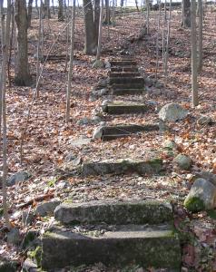
Doodletown, once a small hamlet tucked in a valley between the Hudson River and the summits of five mountains of the Hudson Highlands [Bald, Bear, Dunderberg, The Timp, and West mountains], less than fifty miles from New York City, today has the atmosphere of a ghost town.Cemetery at Doodletown  But scattered remains of two main - now crumbling - roads, walkways leading to front yards returning to their natural state, stone foundations without buildings and interpretive signage about the people and landscape make it a popular destination for hikers.  . 

Doodletown survived as a small, isolated community for about 200 years and would have been part of the Town of Stony Point in Rockland County today.  The area was settled in the 1760s by loggers and miners, and at one time included a church, a school, several small businesses and two cemeteries in addition to 70 houses and 300 residents [at its peak in 1945].  The seven square mile hamlet was ultimately abandoned in the mid-1960s after a long period of land acquisition by the Palisades Interstate Parks Commission.  The Commission had planned to create a cross-country ski network in Doodletown but was never able to start the project. However, at least one community practice dating back to the colonial period survives; burial plots in the cemeteries are still available for former residents and their relatives.  It is an "active" ghost town.

Worth finding and reading: "Doodletown: Hiking Through History in a Vanished Hamlet on the Hudson," by Elizabeth "Perk" Stalter, a former resident of the village. The book is still available inexpensively at the bookstore along the Parkway going to Bear Mountain.  Expensive used copies appear sporadically for sale by popular on-line booksellers. 

Doodletown--the name is said to derive from the Dutch Dood Tal, for "dead valley," with the "town" suffix added later by English-speaking settlers-is part of Bear Mountain-Harriman State Park.  For further information about other hiking and recreational activities in this extensive and varied park click here

Hiking Doodletown walking map

Detailed descriptions of several hikes through Doodletown are available at these links:

Click for a list of detailed hike descriptions in Harriman and Bear Mountain State Parks. It is also possible to search for "Doodletown" while visiting any of these Trail Conference pages.

  •  Other access points also possible - see Harriman-Bear Mountain set of trail maps.


Contact Information:

Palisades Interstate Park Commission

845-786-2701


Directions: 

Take the Palisades Interstate Parkway to its terminus at the Bear Mountain Circle. Continue south on Route 9W for 1.3 miles to a small hikers' trailhead parking area on the left side of the road, just past a concrete bridge over a stream. From the parking area, walk back across the bridge. On the left (west) side of the road, just before a sign for "Ice Skating," turn left at a sign for "Doodletown" and proceed uphill on an old road with crumbling pavement.

Historic: