13. Ferguson Road to Sam’s Point
Section 13: Ferguson Road to Sam's Point
Quick Facts
Distance: 10.9 miles
Parks: Roosa Gap State Forest, Shawangunk Ridge State Forest, Minnewaska State Park Preserve
Maps: Interactive Map, SRT Map 3, Shawangunk Trails (maps 104 and 106B)
Print-Friendly Version: Link
General Description
The Long Path is co-aligned with the Shawangunk Ridge Trail north for the next eleven miles. This section is primarily ridgetop with many spectacular views in all directions. These are among the most dramatic in southern New York. The forest is primarily scrub oak, blueberry and occasional pitch pine. The low forest frequently places the hiker above the trees with unlimited visibility. There are also sections of Shawangunk slab, though not as common as found further north. The trail traverses the ridge to old Route 52, now a woods road, and follows this for a couple of miles until it reaches NY Route 52 and South Gully. The trail then enters Minnewaska State Park, and ascends through South Gully to Sam's Point Preserve.
Access
Take the New York State Thruway to Exit 16, Harriman. Take NY Route 17/future Interstate 86 west 29 miles to Exit 114, Highview. Turn right at the end of the exit ramp onto Old Route 17 (Sullivan County 171) and go uphill for 0.4 miles. Turn left on Shawanga Lodge Road and follow it for about 4 miles. Turn left onto Ferguson Road. The trail crosses the road about 0.7 miles west of Shawanga Lodge Road.
Parking
0.00 Ferguson Road (still called Roosa Gap Summitville Road on some maps), 0.7 miles west of Shawanga Lodge Road). There is limited roadside parking near the trail crossing. (41.61105°, -74.43498°)
0.00 DEC parking lot at the corner of Ferguson and Shawanga Lodge Road (41.60627°, -74.42649°). A trail marked with yellow DEC markers leads in 0.7 miles to the Long Path, just south of Ferguson Road.
0.75 DEC parking lot near the fire tower. It is about 0.1 mile from the parking area to the fire tower. (41.61689°, -74.42567°)
3.50 and 4.70 DEC parking lot on Cox Road (41.64629°, -74.40142°). A red trail leaves the parking lot and connects in 0.85 mi with the Long Path at mile 3.50 when keeping left (west). When keeping right (north), the trail reaches the Long Path in about 1.2 mi at mile 4.70.
5.30 DEC parking lot on NY Route 52. (41.66694°, -74.40406°). From here it is about 0.5 mi to the Long Path, following the red-blazed woods road.
7.80 Route 52, where the Long Path crosses. Several cars can be parked at the woods road (old Route 52) and along Route 52. (41.69251°, -74.39387°)
10.90 Sam's Point Preserve visitor center (fee charged). (41.67012°, -74.36138°)
Camping
Camping on DEC land, which is from mile 0.00 to approximately mile 6.5.
Trail Description
0.00 This section starts at Ferguson Road. Just to the left (west) of the trail, there is room to park several cars. The trail crosses the road about 0.7 miles west of the height of land and parking lot at the corner of Shawanga Lodge Road and Ferguson Road. North of Ferguson Road, the blazes change back to the blue DEC disks. The trail ascends steeply back up to the ridgetop. As you climb, views open up to the south. The ridge north of Ferguson Road is higher and is thus more populated with scrub oak.
0.50 The trail levels out and reaches a spectacular view to the south. This vantage point is higher than any point since the New Jersey border, yielding a view all the way down the ridge to the High Point Monument in New Jersey. There are also views north to the Catskills. From here the trail continues north, remaining about 100 vertical feet below the ridgetop for about one-tenth of a mile, before turning right.
0.60 The trail turns right and reaches the ridge near a fire tower, which is open to the public.
0.75 The Long Path turns left on a road around the fire tower, and soon turns left again to follow the ridge north. The road continues to the right and downhill to the parking area at the end of Fire Tower Road, near the tall emergency tower of Sullivan County.
1.70 A woods road appears on the right. The trail continues north, comes to a boulder and descends east into a col between two ridges of the mountain.
2.15 After a short climb, the trail reaches the top of the lower eastern ridge and turns back north to descend to another col. There is another view from the eastern ridge northwards. The trail continues to descend from the scrub oak and enters the forest.
2.55 The trail descends through an interesting escarpment, and then turns right to parallel it uphill to a height of land. At the height of land, the trail turns left and continues to a woods road. This road connects Cox Road on the east side of the ridge with US Route 209 on the west side of the ridge.
2.90 The trail crosses the woods road and goes through hardwood forest criss-crossed by stone walls, slowly heading uphill in a generally northerly direction. During the next 0.3 miles the trail crosses six stone walls.
3.50 The trail makes a sharp left turn and climbs up the ridge. A trail blazed with red DEC markers goes off to the right and reaches a DEC parking area on Cox Road in 0.85 miles. The Long Path goes through scrub oak with an occasional pine tree. Some of its markings are painted on the rocks. Once on the ridge, the first good views appear with the Shawangunk Ridge and Basha Kill south and the Catskill Mountains northwest. During the next mile the trail winds itself over the ridge, sometimes affording views to the west and northwest, other times northeast to southeast. On the east side of the ridge are steep ledges of 20-40 ft in height and beautiful loose-standing rock formations.
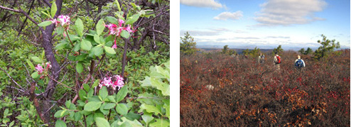
Rhodora (wild azelea). 2007 [ELIZABETH AIVARS]
Wurtsboro Ridge looking north toward the Catskills. 2009 [JAKOB FRANKE]
4.20 An old woods road becomes visible on the bottom of the ledges.
4.60 There are some fine last views of the Catskills, Ellenville, and Bear Hill.
4.70 Another red-blazed trail goes off to the right and reaches Cox Road in 1.2 miles. The Long Path starts heading down through a nice stand of laurel. The trail is quite steep at places.
5.30 Reach an old road blazed with red DEC markers. This road is the former connector between Route 52 in Cragsmoor and NY Route 209 in Spring Glen. The Long path turns left and follows the woods road. Although the first half of the woods road is on DEC land, the Long Path blazes are now LP aqua. (A trail blazed with yellow DEC disks goes right, then left, and in 0.7 mi reaches a DEC parking area on NY Route 52 after crossing a stream with a nice cascading fall, a short climb, and passing a couple of good viewpoints. When following the red-blazed woods road to the right, the same DEC parking area is reached in about half a mile.)
5.60 A red-blazed road leaves to the left and reaches in about a mile another DEC parking area on Old Mountain Road in Spring Glen, off Route 209. The Long Path continues straight ahead.
5.80 The road crosses a stone culvert across a stream in a ravine.
7.80 The woods road reaches NY Route 52. Cross Route 52, and turn left along the shoulder of the highway.
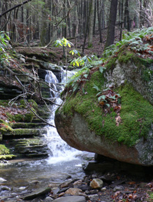
7.85 The Long Path now enters Minnewaska State Park. Turn right into South Gully, at the end of the guide rail, across from two houses. The trail follows an old woods road at the edge of a ravine, and steadily climbs. It comes close to a nice stream with numerous small falls and crosses three side streams before it reaches Gully Road.
9.65 The Long Path turns left on Gully Road, crosses a stream, and immediately turns right into the woods. The trail ascends, makes a switchback near a stream, and steadily keeps climbing.
10.55 Pass a berrypicker cabin.
10.65 The trail reaches the Sam's Point Preserve loop road and continues to the right.
10.90 Reach a split in the loop road. The Sam's Point Preserve parking lot and visitor center are to the right. A parking fee must be paid. The Long Path continues to the left.