15. Port Ben Road to Riggsville
Section 15: Port Ben Road to Riggsville
Alerts
- This section includes a change in the division point between sections 14 and 15 as of Fall 2023.
Quick Facts
Distance: 11.25 miles
Parks: Vernooy Kill State Forest, Sundown Wild Forest
Maps: Interactive Map, Catskill Trails (map 146)
Print-Friendly Version: Link
General Description
Currently this entire section is on roads, but work is in progress to move it off the roads in connection with a DEC Unit Management Plan for Vernooy Kill State Forest and Sundown Wild Forest. The Long Path starts at the Port Ben Road bridge on the north end of Port Ben, a hamlet in the town of Wawarsing, crossing Rondout Creek and continuing to US Route 209. It follows Route 209 for a short distance, turns north on Lundy Road, then east on Rogue (Rouge) Harbor Road, and then north again on Cherrytown and Upper Cherrytown roads to Riggsville. Although this is currently a roadwalk, there are many fine views and interesting features along the way, and vehicular traffic volume is low on most of the roads.
Access
Take the New York State Thruway to Exit 19 near Kingston, then take NY Route 209 west through Kerhonkson, to Wawarsing. In Wawarsing, immediately after crossing the Vernooy Kill, turn left on Port Ben Road, and follow it 0.7 to the bridge that is closed to vehicles. A parking area on state land is on the left (north) side of the road just prior to the bridge.
Camping
On DEC land.
Parking
0.00 Parking area on state land on the north side of the bridge. (41.75082°, -74.35076°)
2.20 DEC parking lot on Cutler Road. (41.76764°, -74.37148°)
11.25 DEC parking lot on Upper Cherrytown Road. (41.86422°, -74.34615°)
Trail Description
0.00 The Long Path crosses the Port Ben Road bridge across the Rondout Creek, which is now closed to vehicles but is open for pedestrians. A parking area is at the northern end of the bridge. For the next 0.3 mile along Port Ben Road, open farm fields provide great views on both sides of the road.
0.70 Turn right onto US Route 209 and cross the Vernooy Kill. The Wawarsing post office is on the right, next to the stream.
0.80 Turn left onto Lundy Road. Be careful, as Route 209 is a very busy road and oncoming west-bound traffic is coming from a curve.
1.20 Pass the last house on the left. The Vernooy Kill is on the left (south) side of the road.
1.30 DEC land starts on the right. In the next half mile, there are a dam and rapids in the Vernooy Kill and opportunities for swimming. Both Lundy Road and upcoming Rogue (Rouge) Harbor Road are very low traffic roads.
2.20 Cutler Road on the left crosses the stream, with a large DEC parking lot on the west side of the bridge. Future plans are to have the Long Path cross the Vernooy Kill here and then proceed north to Vernooy Falls instead of the roadwalk.
2.55 Pass the first of two old homestead sites on the left. The second site is located 500 feet further on the left.
3.05 Turn right onto Rogue (Rouge) Harbor Road (unpaved). The property on the south side of the road is privately owned.
3.35 A large fence appears on the right (south) side of the road.
3.75 The end of the fence.
3.95 DEC land starts on the left (north) side of the road.
4.30 DEC land now is on both sides of the road.
4.55 A tree on the left contains an old sign (facing east) pointing south to Turner Cemetery. About 300 feet off the road, just to the east of a stone wall, are two head stones.
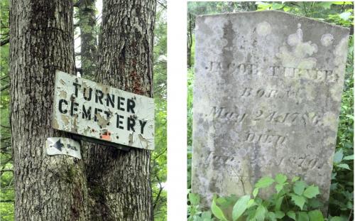
Turner cemetery off Rogue Harbor Road. 2011 [JAKOB FRANKE]
4.75 A DEC parking lot is on the left (north) side of the road.
5.05 End of the DEC lands.
5.35 J&J Road on the right. Rogue (Rouge) Harbor Road becomes paved.
5.70 Woodland Ridge Road on the right. Vehicle traffic may increase.
6.00 The end of Rogue (Rouge) Harbor Road. Turn left onto Cherrytown Road.
7.00 Pass Mt. Laurel Road on the left, continue straight on Cherrytown Road.
8.10 Pass Baker Road on the left.
8.20 Turn left onto Upper Cherrytown Road where Cherrytown Road ends. As it makes the turn, houses are on the left and an old building with garages is on the right.
9.55 Pass White Birch Lane (unpaved private road) on the left, and cross the unsigned Catskill Park boundary.
11.25 The section ends at a DEC parking area on the right side of the road. To continue, turn left and enter the woods on the red-blazed Vernooy Kill Falls Trail.