35. East Berne to John Boyd Thacher State Park
Section 35: East Berne to John Boyd Thacher State Park
Alerts
- The description has been updated with a relocation north of the John Boyd Thacher State Park Visitor Center that was established in summer 2023.
Quick Facts
Distance: 10.95 miles
Parks: John Boyd Thacher State Park
Maps: Interactive Map
Print-Friendly Version: Link
General Description
This section of the Long Path starts pleasantly as it passes through farm country. The section begins where the Long Path crosses NY Route 443 and follows a grassy road past a farm house to reach Stage Road. For the next mile the trail continues though fields and forests until it reaches Sawmill Road. The trail then continues along local roads to John Boyd Thacher State Park. The Long Path follows a series of trails through the park, emerging on the cliffs of the Helderberg Escarpment at the overlook on the north side of NY Route 157. Here, there are spectacular views northeast into Vermont. This ridge is made up of a core of limestone in which were found many fossils during the early days of geology in the 1800s. These fossils are known worldwide for their sequence from the Silurian to the Devonian eras. Early studies in this area helped lay the foundations for modern paleontology and geology. The Long Path then turns north and descends on the historic Indian Ladder Trail under the base of the cliffs, continues north through the park along the escarpment, and then heads in a generally northwest direction through the woods. The section ends at the north end of the park in the parking lot off Old Stage Road.
Access
Take the New York State Thruway to Exit 22 (Selkirk). Turn right on NY Route 144 and continue south to NY Route 396. Turn right on Route 396 and follow it 6 miles to South Bethlehem, where Route 396 ends and the road becomes Albany County Route 301. Follow Route 301 west another 6 miles to its end at NY Route 443 in Clarksville. Turn left on Route 443 and follow it west about 5 miles to the second intersection with Stage Road, 1.5 miles from the intersection of NY 443/85.
Parking
0.00 Stage Road, near the intersection with NY Route 443, about 0.1 mile east of the trail. (42.60218°, -74.04600°)
3.50 John Boyd Thacher State Park parking area on Beaver Dam Road. (42.63870°, -74.01524°)
4.55 Lower Paint Mine Picnic Area (about 0.2 miles off the trail). (42.65111°, -74.01632°)
5.20 Helderberg Escarpment Overlook parking area. (42.65248°, -74.01204°)
6.20 North end of Indian Ladder Trail. (42.65481°, -74.01787°)
10.95 Old Stage Road (limited). (42.68158°, -74.05442°)
Trail Description
0.00 The Long Path crosses NY Route 443 just east of the driveway of a private residence and heads uphill in a northeasterly direction along the edge of a large field. The trail climbs gradually and passes a farm house on the left when it reaches Stage Road.
0.15 Reach Stage Road and continue straight to follow the road through farm fields.
0.40 Turn left at a hedgerow bordering a field, crossing a short bridge over the drainage ditch. The trail descends gradually north along the west side of the hedgerow. There is an expansive view west, across open fields, toward Cole Hill and the Schoharie Valley.
0.80 Bear right through a gap in the hedgerow, then enter a young hardwood forest.
0.95 Reach Sawmill Road opposite its intersection with Stempel Road, and turn left (north) to follow Sawmill Road.
1.30 Turn right (east) onto Long Road.
2.35 Turn left at Elm Drive.
2.50 Bear right onto Bush Drive.
3.25 Turn right onto Beaver Dam Road (Albany County Route 303).
3.50 Turn left off the road into the woods at a trailhead for John Boyd Thacher State Park. Parking is available for several cars along a wide gravel shoulder. In about 200 feet, turn left (west), now following a coaligned blue-blazed trail.
3.90 Bear left as the blue-blazed trail turns right. Soon cross a small stream and pass a white connector trail.
4.10 A Nature Trail joins from the right at the head of a ravine. The Long Path and coaligned Nature Trail continue ahead, gradually descending on the left side of the ravine.
4.40 Turn right at a junction with a white connector trail. The white connector trail continues straight to reach the Lower Paint Mine picnic area and pavilion in 0.15 mile. The Long Path crosses the ravine on a bridge and follows the lower part of the Nature Trail. In 0.1 mile, the Natural Trail forks to the right, but bear left to remain on the Long Path and pass through a dense hemlock forest.
4.85 Turn left to follow a woods road that leads into the Upper Knowles Flat Picnic Area. The trail follows the north edge of the picnic area, then descends right on a gravel path to the paved access road. The trail then turns right onto the access road toward NY Route 157.
5.15 Cross NY Route 157 and reach the Overlook parking area. The trail turns left and follows the overlook along the edge of the escarpment, with spectacular views across the upper Hudson Valley to the Green Mountains of Vermont and the Adirondacks of New York.
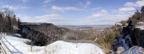
Panorama from Thacher Park lookout. 2001 [HERB CHONG]
5.40 Reach the northern end of the parking area, and continue to follow the escarpment fence through the woods. About about 0.2 mile, emerge from the woods to reach a view over Mine Lot Falls, which plunges over the escarpment, near La Grange Bush parking lot.
5.70 Reach the southern end of the Indian Ladder Trail, which descends stairs to the right. Note the Indian Ladder Trail is only open from mid-May to late fall, as it is dangerous when there is ice; the Long Path follows the Indian Ladder Trail when it is open, but follows the path along the top of the escarpment (which passes another overlook and the top of the falls) during the remainder of the year. When open, turn right onto the Indian Ladder Trail and descend a series of stairs. At the base of the stairs, follow the bottom of the escarpment northward under the cliffs, passing under Mine Lot Falls and another waterfall (the water flow for each is very variable, so they can be just a trickle during dry periods). The trail then reaches another set of stairs that climbs back up to the top of the escarpment.
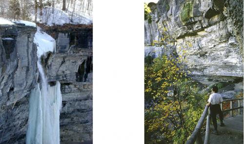
Mine Lot Falls in the winter. 2001 [HERB CHONG] Base of the Indian Ladder Trail. 2001 [MICHAEL WARREN]
6.20 Reach the northern end of the Indian Ladder Trail. To the left is the Visitor Center, which is worth a short detour. The Long Path turns right to follow the Escarpment Trail, which follows the escarpment fence and offers periodic views through the trees.
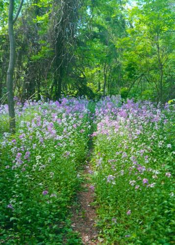
Wildflowers growing near the ranger station. 2001 [LOREN DOBERT]
6.50 Reach a viewpoint along the escarpment and picnic area near the Horseshoe 1 parking area. The trail continues following the escarpment as it loops around this horseshoe-shaped section.
6.80 To the left through the trees is the Horseshoe 2 parking area.
7.20 Reach another panoramic viewpoint over the escarpment near the northern end of the Hailes Cave parking lot. In a short distance, the trail passes a rock climbing area entrance called Squeeze Box and then turns left away from the escarpment, crosses Hailes Cave Road, and soon reaches a grassy road. Follow this road as it continues through an open area.
7.35 Turn right off the grassy road into the woods. This section of trail includes many narrow fissures, some very deep, that crisscross the woods. The trail parallels and then crosses a stone wall to reach an old woods road.
7.55 The trail turns right on the old road and enters the OSI Thacher Park Nature Preserve.
7.75 The Long Path turns left off the woods road to climb along a switchback to the top of the ridge and a junction with another woods road.
7.85 The trail meets a yellow-blazed woods road leads left in 0.3 miles to Ryan Road and a small parking area. The trail turns right and follows the crest of the ridge through a mixed forest of pine, hardwoods and low-growing juniper.
8.25 After reaching a cairn that marks the highest point on this trail section, about 1,410 feet, the Long Path descends gradually from the escarpment, staying near its edge.
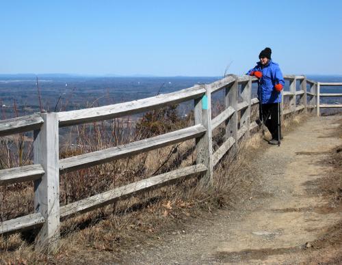
View from the escarpment in John Boyd Thacher State Park. 2010 [JAKOB FRANKE]
8.65 The Long Path reaches a junction with another trail (blazed white) and turns right, descending steeply to a gravel road used by hang-glider enthusiasts to access a take-off pad at the edge of the escarpment. Turn left on the hang-glider road. (To reach the hang-glider launch site, continue straight ahead on the road at this point.)
8.85 The trail leaves the hang-glider road and bears right, circling a depression in the escarpment.
9.15 The trail crosses an old stone wall.
9.25 Reach the middle of an old juniper stand and turn right. The forest along the trail is laced with fascinating fissures caused by acidity eating away the escarpment’s limestone.
9.35 A red-blazed trail joins the Long Path from the left. Both Long Path and red blazes now mark the trail. It is important to remain on the trail in this area, to avoid potential injury from stumbling into a fissure.
9.75 The trail reaches a point where it turns sharply left, heading west. Just ahead and to the right is an open 'High Point' viewpoint. To the right Mt. Everett in southern Massachusetts is seen peeking over the shoulder of the hang-glider opening. Panning north you will see Albany, Mt. Greylock, the Town of Altamont, and Vermont’s Green Mountains with Killington and Pico Peak prominent.
9.95 The Long Path crosses a white-blazed woods road. The Long Path continues past a stone wall to the left onto a segment of an old woods road, then bears left away from the woods road through mixed deciduous and evergreen forest, winding through several stands of hemlock.
10.25 The Long Path turns right, leaving the red-blazed trail, and skirts fields and stone walls on the left.
10.45 The Long Path crosses a woods road leading to a field on the left and then skirts the edge of the field.
10.65 The trail crosses a field and then re-enters the woods, passing through many stands of hawthorne bushes.
10.75 The Long Path parallels a stone wall, and then joins an old woods road that also leads to the ‘High Point’ overlook already encountered.
10.95 Reach a parking area off Old Stage Road marking the furthest extent of park property, and turn right.
This is currently the "End-to-End" end of the Long Path. The trail has been blazed across the Mohawk River to the Saratoga County line, and from there a route has been described to the Adirondacks blue line, but until more of that route is off-road those sections are not a requirement for the "End-to-End" certificate.
Previous Section: Section 34
Next Section: Section 36