34. Switz Kill to East Berne
Section 34: Switz Kill to East Berne
Alerts
- No current alerts.
Quick Facts
Distance: 9.2 miles
Parks: Cole Hill State Forest
Maps: Interactive Map
Print-Friendly Version: Link
General Description
This section of the Long Path is a pleasant blend of ski trails in the state forest, road walking and woodland trails. The Long Path leaves the valley of the Switz Kill and goes along Willsie Road to the top of Cole Hill, where it follows a series of recently constructed ski trails through a mature forest. There are views from Cole Hill, and the trail passes several beaver ponds that have the feeling of the Adirondacks. Past Cole Hill, the Long Path goes along public roads, with a view of the Catskills in the distance. Upon reaching the Doppler weather tower for the Albany region, the trail reenters the woods and begins a gradual descent through land that was once farmed. The Long Path passes through a field, crosses Joslyn School Road, and descends through a pine forest. It then crosses Fox Creek and finally emerges on NY Route 443.
Access
Take the New York State Thruway to Exit 22 (Selkirk). Turn right on NY Route 144, and continue south to NY Route 396. Turn right on Route 396 and follow it for 6 miles to South Bethlehem, where Route 396 ends and the road becomes Albany County Route 301. Continue on Route 301 west another 6 miles to its end at NY Route 443 in Clarksville. Turn left on Route 443 and follow it 11 miles to the village of Berne. About a mile west of Berne, turn left on Albany County Route 1 and follow it south about 4 miles to Gifford Hollow Road.
Parking
0.00 Switz Kill Road (Albany County Route 1) and Gifford Hollow Road. (42.57715°, -74.11854°)
3.10 Turnoff on right side of Irish Hill Road. (42.59720°, -74.11107°)
4.15 Willsie Road. (42.59349°, -74.10602°)
5.10 Cole Hill Road. (42.59456°, -74.09527°)
7.00 Woodstock Road at weather station. (42.58694°, -74.06354°)
9.20 Stage Road, near the intersection with NY Route 443, about 0.1 mile east of the trail. ( 42.60218°, -74.04600°)
Camping
2.75 Camping is allowed in Cole Hill State Forest 150 feet away from the trail and from water.
Trail Description
0.00 The Long Path leaves the Switz Kill Valley at the intersection of Switz Kill Road and Gifford Hollow Road and begins to climb following Switz Kill Road.
0.65 Reach Willsie Road, turn left and head uphill, following paved Willsie Road. Near the top of the hill, there is a view back to Partridge Run and the Catskills.
2.10 The trail reaches the southern boundary of Cole Hill State Forest and enters the woods on the left across from a small parking area. It proceeds westward, descending to a small stream and crosses it on a bridge. Beyond the stream, the trail ascends, gradually swinging towards the northwest and then turning to the north at the top of the slope. It then enters a reforested area and passes through alternate fields of pine and spruce, each separated by mixed hardwoods and stone walls. After the fourth stone wall, the trail turns right (east) on a fire access road to join a cross country ski trail.
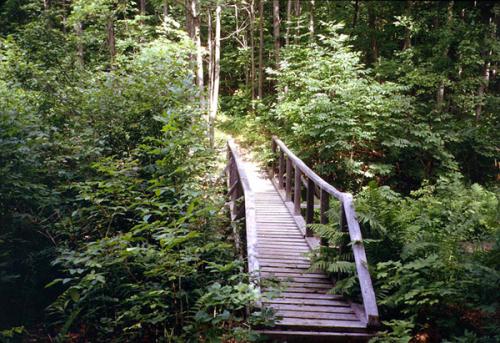
Bridge in Cole Hill State Forest. 2001 [ED WALSH]
3.10 The trail crosses Irish Hill Road. There is a parking area at the north side of this crossing. The trail is mostly marked in the standard aqua paint blazes, but there are also DEC ski trail markers and red trail markers.
3.25 The Long Path reaches a 2015 clear-cut area and turns left on an intersecting trail. After a short distance, it turns right, crosses a stone wall, and follows the top of an escarpment.
3.45 Reach an overlook over the escarpment, with views west over the Switz Kill Valley to Partridge Run. Just past the overlook, cross another stone wall and turn left on an old woods road.
3.75 Reach the boundary of the state forest, where the trail turns right. Remain within the forest, as a woods road to the left leads into private property.
4.05 Begin to descend. Turn left on yet another ski trail, then turn right and continue to descend to Willsie Road.
4.15 Cross Willsie Road and re-enter the woods. In another 500 feet, the trail turns left, and then turns right to begin a series of corduroy, stepping stones and a foot bridge.The trail begins a gradual ascent and turns left.
4.50 The Long Path passes through a deep forest known locally as the “Avenue of the Pines.” At the far end of this forest, there is an opening in the woods, with a view to an abandoned beaver pond. This old pond is now a wetland filled with marsh grass.
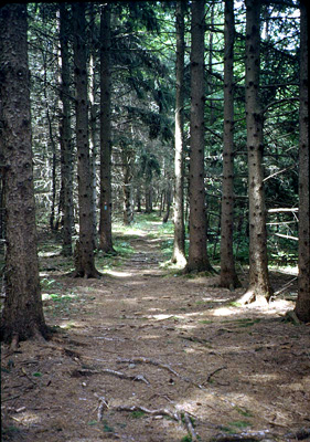
Avenue of the Pines. 2001 [ED WALSH]
4.70 Reach another beaver pond in a beautiful pine forest, a wonderful lunch spot. Here, the Long Path turns left and crosses a substantial bridge. The scene here is quite reminiscent of the Adirondacks. Beyond the beaver pond, the trail climbs steeply to a hemlock grove, briefly turns left on an old woods road, and then ascends to Cole Hill Road.
5.05 Turn right and continue uphill on paved Cole Hill Road. There is a parking area here. In the future, it is anticipated that the Long Path will be rerouted through the woods in this area, but for the present, it follows public roads for about 2 miles.
5.45 Reach the crest of Cole Hill Road, with views south toward the Blackhead Range and Windham High Peak in the Catskills. As you continue on Cole Hill Road, the view opens up to include Mt. Hayden, Mt. Pisgah, Richmond Mountain, Ashland Pinnacle and Huntersfield Mountain, the route of the Long Path as it heads northwest from the Catskills to Schoharie County.
5.90 Turn left on Woodstock Road, and pass Woodstock Lake Campground, a large private campground and RV park, to the right.
6.75 Reach intersection with Filkins Hill Road to the left, but continue straight on Woodstock Road.
6.95 As Woodstock Road turns right, the Long Path continues straight ahead on a gravel road that leads to a weather station.
7.10 Pass the National Weather Service's Albany Region Doppler radar tower on the right. This tower tracks and warns of severe storms. Vehicles may not be driven beyond this point. The Long Path descends from Stafford Hill on a narrow woods road, with a rock ledge on the left at the bottom of the hill.
7.40 Continue straight ahead on an older woods road, as the road that the Long Path has been following turns left. In 500 feet, bear right at a fork, and begin a gradual descent through dense foliage.
7.65 Reach an intersection, with a gravel road to the right, and a level ATV track to the extreme left. The Long Path crosses both roads and descends slightly to the left. If you are going in the opposite direction, continue straight ahead across the gravel roads. You will know that you are following the correct route if you pass between the “Posted” signs of two different landowners. After a slight descent, the trail bears right, following an old woods road.
7.80 The Long Path crosses a seasonal wet area on stepping-stones, and then turns left across level terrain. In 0.2 miles, the trail begins a gradual descent, and then intersects a stone wall that it follows downhill, descending more steeply.
8.40 Turn right along a row of pines above a stone wall and a logging road, parallel to the edge of a field.
8.60 Turn left to enter the field and head downhill to a hedgerow of mature trees parallel to Joslyn School Road. There are very nice views of the farm and a pond, as well as views across the road to Pinnacle Mountain.
8.70 At the northern end of the hedgerow, reach Joslyn School Road and turn left (north) to follow the road. In 100 feet, turn right to cross Joslyn School Road across from a driveway to a barn, then turn left to follow the field edge parallel to the road. At the edge of the field, turn right onto a farm road then quickly turn left into the woods in about 20 feet. The trail parallels Joslyn School Road for a short distance before turning right through large red pines.
8.90 Turn left at log steps and soon follow a field edge with nice views to the west over the field. Descend to cross a wide, planked bog bridge, then follow another field edge along the top of an old stone wall. Some of the stones in the wall can shift as you walk on them. The trail then turns away from the field.
9.10 Cross a snowmobile bridge over Fox Creek, then turn left along the edge of a field to climb toward NY Route 443.
9.20 Climb a short set of stairs to reach NY Route 443, where this section ends. Cross the road and then follow the edge of a driveway to continue on the next section.