26. NY Route 23 to Greene County Route 10
Section 26: NY Route 23 to Greene County Route 10
Quick Facts
Distance: 7.2 miles
Parks: Elm Ridge Wild Forest, Mount Hayden State Forest, NYC DEP watershed land
Maps: Interactive Map, Catskill Trails (maps 141 and Long Path North)
Print-Friendly Version: Link
General Description
In this section, the Long Path leaves the Catskill Park after a journey of 94 miles and continues to the north. The terrain is similar to that found in the Catskills, but on a smaller scale. The primary ridge followed by the trail in this section is a continuation of the Catskill Escarpment. For some of the distance along the ridge the trail follows logging roads. The area is still alive with logging activity, but the forest recovers quickly where there has not been any clear cutting. There are no great open views, but there are many good views along the way when the leaves are down. The trail crosses two notches, Jennie and Barlow, which are bisected by the remnants of old mountain turnpikes that connected the mountains to the valley to the east. The first 0.75 miles of the section goes through state land and is marked with blue DEC trail markers, while the rest of the section is on a mixture of NYC-DEP land, Trail Conference land, and state land, and is marked with aqua Long Path paint blazes. On the NYCDEP lands lands, no camping and no fires of any kind are permitted.There are no water sources in this section along the ridge.
Access
Take the New York State Thruway to Exit 21 (Catskill). Continue on NY Route 23 west approximately 20 miles to East Windham. About 0.5 miles past the "Entering Catskill Park" sign, there is a DEC parking area for the Escarpment Trail and Windham Mountain at the intersection of Route 23 and Cross Road.
Parking
0.00 Parking area on NY Route 23 in East Windham, at intersection with Cross Road. (42.31280°, -74.19024°)
1.35 NYC-DEP parking area at the end of Jennie Notch Road, past the first gate (which is kept open). (42.32789°, -74.18847°) Do not park on the road near the house.
6.55 Intersection of Sutton Road and Cunningham Road. (42.37305°, -74.22457°)
7.20 Greene County Route 10, about 200 feet north of the trail intersection. (42.37532°, -74.23265°)
Trail Description
0.00 From the intersection of NY Route 23 and Cross Road proceed north on Cross Road for about 150 feet, just beyond the DEC parking area. The Long Path, blazed with blue DEC trail markers, then turns right, crosses a small field and enters the woods. The trail continues east, parallel to Route 23, crosses a stone wall, passes through a swampy area and then crosses another stone wall.
0.30 Here we leave the Catskill Park, which the Long Path has traversed for the last 94 miles. The trail turns left, away from Route 23, and ascends gradually to an old spruce and hemlock forest. From here, the trail descends gradually to the left.
0.75 Cross Old Road and continue north on Jennie Notch Road. The Long Path now leaves state land, and for the remainder of the section it is marked with aqua paint blazes.
1.30 After passing several houses, Jennie Notch Road officially ends at an old red brick house. The trail passes through an open gate onto NYC-DEP land and continues along a gravel road to the DEP parking lot and a closed gate. The gravel road becomes overgrown as it follows the route of an old 19th century mountain turnpike uphill to Jennie Notch.
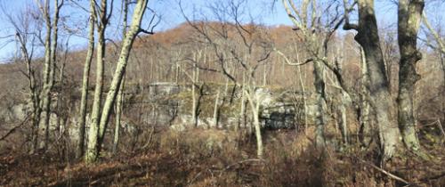
Escarpment off the Jennie Notch Road extension. 2012 [JAKOB FRANKE]
2.10 Passing through another open gate, the trail leaves DEP land and enters land owned by New York New Jersey Trail Conference. In this area there are limited views across the valley to Windham Mountain.
2.35 At the height of land, the trail turns sharply to the left and begins a steep climb up Ginseng Mountain frequently turning on and off old logging roads. After a small downhill and another steep uphill, there are some snatches of views to the northeast across the lowlands toward Albany. The trail passes north of and below the summit of Ginseng Mountain.
2.80 The trail descends and crosses onto state land (yellow survey blazes). The trail is on state land for the rest of the section, but often follows close to the border with NYC-DEP land (red survey blazes).
3.30 After descending a rock step, the trail follows a logging road along the level for a while, then turns left off the logging road and soon passes between some large rocks. At the end of the mostly level stretch the trail turns sharply right and climbs steeply up an unnamed knob.
3.70 Reach the top of the knob. The trail now descends steeply, passing a view to the north just before descending a steep switchback through a rock ledge.
4.00 Barlow Notch. Here the trail crosses another mountain turnpike and passes through a level area in the notch. The trail then descends slightly in order to stay on state land as it heads north out of the notch.
4.05 Sutton Memorial. The trail turns sharply left, crosses a logging road, and begins a steep switchback ascent up to the ridge.
4.30 The trail reaches a shoulder of the ridge and levels out for a bit. There are winter views of Lake Heloise through the trees to the southwest. Soon the trail begins climbing again, but less steeply.
5.00 After traversing the summit plateau, the trail passes about 100 feet south of the true summit of Mt. Hayden, where it makes a sharp left turn and begins to descend. It leaves the summit on a round about route to avoid cliffs and a former land boundary, and eventually heads down the north ridge.
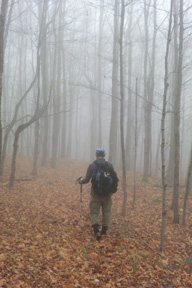
Foggy woods. 2012 [JAKOB FRANKE]
5.50 After descending steadily, the trail reaches the top of a steep sidehill down an extremely steep slope. This stretch may be treacherous in snow. There are views through the trees to the north at the top of the steepest area. After about a tenth of a mile, the sidehill ends and the trail descends a little less steeply.
5.80 The trail turns left onto an old logging road and levels out. Midway through the level stretch the logging road angles off downhill to the right but the trail continues level.
6.20 At the end of the level stretch, the trail steps off a short rock ledge and begins a steady descent to Sutton Road.
6.55 Turn left onto dirt Sutton Road close to its fork with Cunningham Road. Cross both roads and re-enter the woods. The trail turns left and angles away from Cunningham Road, descending gradually to a small stream crossing. Soon a second small stream is crossed, but both of these streams may be dry in late summer.
7.20 After a brief climb, reach Greene County Route 10. Turn right (north). In about 200 feet there is a parking area on the east side of Route 10. To continue, cross Route 10 before the parking area and proceed uphill into the woods.