19. Wittenberg Mountain to Phoenicia
Section 19: Wittenberg Mountain to Phoenicia
Quick Facts
Distance: 9.85 miles
Parks: Slide Mountain Wilderness
Maps: Interactive Map, Catskill Trails (map 142)
Print-Friendly Version: Link
General Description
The Long Path follows a trail along the foot of Wittenberg Mountain and reaches a spectacular viewpoint before descending to Cross Mountain. It is a pleasant hike along Cross Mountain, which is nothing more than a long ridge connecting Wittenberg Mountain with Mount Pleasant. There are several good views of Wittenberg and the Ashokan Reservoir along the way. The trail then passes over Mount Pleasant, about a quarter mile west of the summit, with more nice views of Wittenberg Mountain and a view to the east. Following a series of switchbacks, the trail starts ascending Romer Mountain. From the summit of Romer Mountain, it is a three-mile descent before reaching the DEC parking area at the foot of Romer Mountain. The trail continues on local streets east along the Esopus Creek, and crosses the Esopus into the Village of Phoenicia.
Access
Take the New York StateThruway to Exit 19 (Kingston). Follow NY Route 28 west for 23 miles to Phoenicia. Turn right at the first turn to Phoenicia (Bridge Street). Follow Bridge Street to just before the railroad tracks, and turn left onto High Street. Follow High Street and then Woodland Valley Road 6 miles to the Woodland Valley State Campground. It is a 2.75-mile hike from the campground to the Long Path.
Parking
0.00 Woodland Valley State Campground (parking fee charged in season) (42.03576°, -74.36531°). It is 2.75 miles from the parking lot to the Long Path.
9.10 DEC parking area at Lane Street, Phoenicia. (42.07825°, -74.31913°).
9.85 Village of Phoenicia (parking available on Main Street or behind the Phoenicia Pharmacy on NY Route 214).
Camping
0.00 Woodland Valley State Campground (fee charged). It is 2.75 miles from the campground to the Long Path.
0.00 Terrace Mountain Lean-to (1.05 miles from the Long Path on yellow-blazed Terrace Mountain Trail; no water).
9.85 Black Bear Campground, 17 Bridge Street, Phoenicia; Tel. 845-688-7405.
Trail Description
0.00 From the trail junction, the Long Path follows a section of the Phoenicia–East Branch Trail (constructed by volunteers and opened in June 2014) which is blazed with blue DEC markers. The trail passes through an area that is occasionally wet. In about half a mile, the trail crosses a small stream that often has water.
0.85 Another seasonal stream crossing.
1.15 The trail reaches a spectacular viewpoint on the cliffs. Wittenberg Mountain is rising in the back, Panther Mountain is visible, as are the entire northern Catskills, and from a cliff slightly below, the Ashokan Reservoir can be seen. The trail descends steeply after the viewpoint and in about 0.2 mile passes the Grand Staircase, a series of beautiful rock steps. Past the Grand Staircase, the trail reaches the col between Wittenberg and Cross Mountains. The next couple of miles are mostly ridge walking, with several viewpoints near the summit of Cross Mountain.
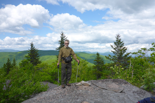
View of the Devils's Path. 2014 [JAKOB FRANKE]
2.25 A short side trail (currently unmarked) leads to a good viewpoint. In a few hundred feet, when the trail makes a sharp left turn, there is another short side trail (unmarked) straight ahead through a field of ferns to a viewpoint.
2.35 View from the trail of the Ashokan Reservoir and Samuels Point.
2.40 Another side trail (unmarked) to the right leads to a viewpoint.
2.50 The Long Path reaches the summit of Cross Mountain. The trail starts slowly descending and passes over low cliffs and through several open areas where brambles and blueberries can be found. In about 3/4 mile the trail reaches the col between Cross Mountain and Mount Pleasant and passes through a relatively dark and cool forest, until the trail starts ascending again.
4.00 The trail reaches a fine viewpoint to the west, with Wittenberg and Panther Mountains in full view. The trail then veers to the east side of the ridge, passing a seasonal spring in about 0.1 mile.
4.40 A viewpoint to the east is reached. Below, the Route 28 corridor with the Emerson Resort is visible. The trail swings back to the west side of the ridge.
4.70 Another fine view to the west. Past this view, the trail follows the cliff line for a short while, than slowly descends to the col between Mount Pleasant and Romer Mountain. In the next mile, several switchbacks are passed, after which the trail starts to ascend.
5.75 The trail passes another unmarked side trail to a fine viewpoint to the east.
5.90 The trail reaches the summit of Romer Mountain.
6.70 The trail reaches a cliff, with a seasonal view to the west.
7.10 The trail passes through an interesting crevice and keeps descending, following on occasion stretches of old woods roads.
8.20 The trail crosses a wet area on rock slabs installed by one of the volunteer trail crews.
8.30 The trail turns left onto a woods road. To the right, the woods road leads to an old bluestone quarry.
8.55 The trail makes a sharp left turn. Straight ahead is a short side trail to a pipe spring.
9.10 The Long Path reaches a DEC parking lot at the end of Lane Street. The trail continues out of the parking lot on a local street (Lane Street) and turns left.
9.30 The Long Path turns right on High Street, which runs parallel to Esopus Creek. It crosses under NY Route 28 and intersects Bridge Street.
9.65 The Long Path turns left on Bridge Street, crosses the railroad tracks and then Esopus Creek, and enters Phoenicia. Black Bear Campground is off Bridge Street on the right. The railroad tracks, formerly the route of the Ulster and Delaware Railroad, which once brought trainloads of tourists to this portion of the Catskills. Today, Rail Explorers offers railbike rides from Mt. Pleasant to Phoenicia (www.railexplorers.com).
9.85 Reach Main Street in Phoenicia (Ulster County Route 40). To the left is the center of Phoenicia. While just two blocks long, it is well worth the detour. It is the home of several restaurants and a number of antique shops. There is also a grocery and general store for backpackers to resupply, as well as a B&B. To continue on the Long Path, turn right and proceed eastward on Main Street (Ulster County Route 40).
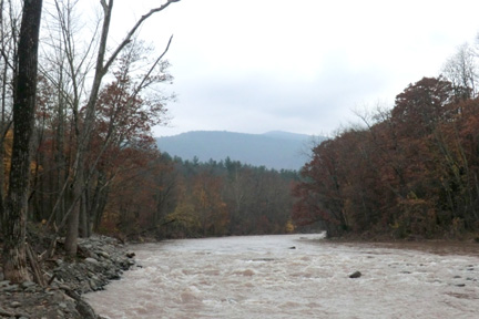
Esopus Creek in Phoenicia. 2012 [JAKOB FRANKE]