6. Lake Skannatati to US Route 6
Section 6: Lake Skannatati to US Route 6
Quick Facts
Distance: 10.15 miles
Parks: Harriman State Park
Maps: Interactive Map, Harriman-Bear Mountain Trails (map 119)
Print-Friendly Version: Link
General Description
This section of the trail continues through Harriman State Park. The Long Path crosses many woods roads and other trails within the park, making possible various loop hikes. The trail traverses hemlock forests and rhododendron groves, and passes by large swamps. It then climbs and follows along the long, linear ridge of Stockbridge Mountain. Upon descending from the mountain, the trail passes another swamp before reaching US Route 6.
Access
To reach the beginning of the section from the New York State Thruway, take Exit 15 (Suffern). Continue north on NY Route 17 to Sloatsburg. Just north of the village, turn right onto Seven Lakes Drive. This section starts at the fishing access parking lot off of Seven Lakes Drive at Lake Skannatati, about 0.75 mile north of Kanawauke Circle. From the Palisades Interstate Parkway, take Exit 15, go west on Gate Hill Road and Rockland County Route 106 to Kanawauke Circle, and then go north for 0.75 mile on Seven Lakes Drive.
Parking
0.00 Lake Skannatati parking area. (41.241979°, -74.102427°)
5.75 Tiorati Circle picnic area, about 0.5 mile east of the Long Path crossing of Arden Valley Road (fee charged seasonally). (41.275190°, -74.089036°)
10.15 Parking area off Route 6. (41.315976°, -74.050148°)
Camping
4.45 Cohasset Shelter
8.00 Stockbridge Shelter
Trail Description
0.00 The section begins at the Lake Skannatati parking area off Seven Lakes Drive. Follow the shore of Lake Skannatati north through the parking area. At the northeast end of the lake, where the Arden-Surebridge Trail (A-SB) (red triangle on white) starts on the right, turn left into the woods and follow the north shore of the lake. About halfway along the north shore, the Long Path veers away from the lake, goes over a small ridge and drops back to the west arm of the lake. After undulating up and down along the lake's western shore, the trail crosses the lake's swampy inlet stream and begins a series of longer ups and downs.
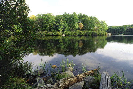
Lake Skannatati. 2001 [MICHAEL WARREN]
1.25 The Long Path turns left and joins a woods road, the route of the Dunning Trail (yellow). In 250 feet, the Long Path turns right on a footpath, as the Dunning Trail continues along the woods road. The Long Path goes over a grassy ledge perched on a hill slope and passes a shaft of the abandoned Hogencamp Mine, one of the largest iron mines inside the Park boundary. Stone foundations on the side of the trail are remnants of this mining community.
1.40 The trail turns right near an overhanging rock, known as Cape Horn, to continue up an old stone-lined road. After passing through a saddle, the trail begins to descend through forest rich in hemlock and mountain laurel. It joins an old woods road, the continuation of the Surebridge Mine Road.
2.00 Reach Times Square, the junction of the Long Path, the A-SB Trail (red triangle on white) and the Ramapo-Dunderberg Trail (red dot on white). The Long Path continues west jointly with the A-SB Trail on the Surebridge Mine Road through fairly level terrain.
2.10 The Long Path and the A-SB Trail turn left, leaving Surebridge Mine Road, and rise gently through a forest of hemlock and white pine. Surebridge Swamp becomes visible below on the right. The trail now alternates through laurel, hardwoods, hemlocks and large rhododendrons.
2.60 The Lichen Trail (blue L on a white square) starts to the left as the Long Path and A-SB continue on a downgrade to pass a swampy area on the right. The trails approach and veer away from a hemlock swamp and then run along the swamp's intermittent outlet stream before crossing the stream. The descent ends as the combined trails begin to pass a marsh on the right.
2.90 The White Bar Trail (horizontal white rectangle) starts to the left. In another 30 feet, the Long Path turns right as the A-SB continues straight ahead along the side of a marsh. The Long Path crosses an outlet stream and runs between the marsh and a steep, hemlock-covered slope. Upon reaching the head of the marsh, which becomes a wooded swamp, the trail follows an inlet stream. The trail then turns left and uphill, away from the stream.
3.60 Cross the Appalachian Trail (vertical white 2x6 rectangle) in a slight dip at a prominent signpost. The sign has distances to various landmarks on both the Long Path and Appalachian Trail routes. The Long Path now rises to a broad knob, dips to a marsh, and climbs a knoll.
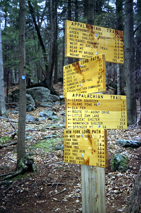
Appalachian Trail Junction. 2001 [ED WALSH]
4.30 The trail reaches the top of the knoll and begins to descend, passing a partial view of Upper Lake Cohasset on the way down.
4.45 Pass Cohasset Shelter (no water), on the left as the descent continues. This shelter was built in 1937 for the girls' camps on Upper Lake Cohasset. The trail crosses Surebridge Mine Road and, in another 0.25 mile, crosses a stream leading from a marsh on the right to Upper Lake Cohasset. The trail now crosses a series of intermittent streams and boulder fields as it approaches the road.
5.75 Cross Arden Valley Road at a horseshoe bend. The Long Path jogs left to cross the pavement opposite a wide woods road. Follow this woods road as it passes to the left of a beautiful hardwood swamp.
6.15 After the swamp ends, the Long Path climbs to the left as the woods road continues straight ahead to the AT and the Ramapo-Dunderberg Trail. The trail now ascends to the long ridge of Stockbridge Mountain. Once on the bedrock outcrop of the ridge, the trail follows the gentle ups and downs of the crest northeast.
7.80 The trail passes under a large cantilevered rock, known as Hippo Rock, which juts toward the trail from the west.
7.90 The Menomine Trail (yellow), which leads to the Silvermine picnic area, leaves to the right in a valley.
8.00 The trail reaches the Stockbridge Shelter, which is a handsome rock-and-mortar structure with a plank floor. It sits on a rock outcrop with a fine view to the south. No water is available.
8.30 The Long Path drops steeply over a boulder slope. The Cave Shelter is set into an overhang near the base of its rock face. It is damp and hardly an inviting place to spend the night. Again, no water is available. From here, the trend is downhill to US Route 6. As the descent progresses, trees get larger and form a closed canopy; blueberry becomes more dominant in the understory.
9.10 The trail turns left and passes to the left of a small knob that is the point of a large saddle. After crossing from the right to the left side of a valley and back again, the trail climbs out of the valley. It reaches and turns left on a woods road to US Route 6.
10.00 The trail crosses US Route 6 and continues up the exit road from the parking area on the north side of Route 6. (This road is the old Route 6, used until 1967, when the present road was opened to traffic).
10.15 The section ends shortly after the pavement widens to allow parking. There is kiosk here with a description and map of the Long Path. To continue, turn left and enter the woods.