From the parking area, walk north along the grassy shoulder of the road. Soon, you will see a triple-orange blaze, which marks the start of the Butter Hill Trail. Follow the orange blazes as they bear right, away from the road, and begin to ascend steeply. Soon, views over the Hudson River begin to appear to the right. The mountain across the river is Bull Hill (Mt. Taurus), and the point of...
Hike Description:
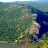
From the parking area, walk north along the grassy shoulder of the road. Soon, you will see a triple-orange blaze, which marks the start of the Butter Hill Trail. Follow the orange blazes as they bear right, away from the road, and begin to ascend steeply. Soon, views over the Hudson River begin to appear to the right. The mountain across the river is Bull Hill (Mt. Taurus), and the point of land jutting into the river is Little Stony Point.
In 0.2 mile, you'll reach three stone pillars, with a stone foundation behind the pillars. These are the remains of Spy Rock House, the summer cottage of Dr. Edward L. Partridge, who served on the Palisades Interstate Park Commission from 1913 to 1930. The trail now descends slightly, then continues to climb Butter Hill, first gradually, then more steeply. At the top of the steep climb, you'll reach open rock ledges that afford a wide panorama to the east, south and west. Route 9W is visible straight ahead to the south, with the North Ridge of Crows Nest Mountain to its left. The Hudson River is to the east. You'll want to pause here for a little while to enjoy this expansive view, but the best is yet to come.
After a short level stretch, the Butter Hill Trail ends at a junction with the yellow-blazed Stillman Trail, also the route of the teal diamond-blazed Highlands Trail (some of the blazes at the junction are blue diamonds). Turn right and follow the Stillman Trail up to the summit of Butter Hill, where a rock outcrop just to the left of the trail provides a 360-degree view. The East Hudson Highlands are visible across the river, with towers marking the summits of Beacon Mountain to the north. Bull Hill is directly to the east. On the west side of the river, the North Ridge of Crows Nest Mountain is directly to the south, with Black Rock Forest visible to the southeast. Schunemunk Mountain may be seen to the west, with the Moodna Viaduct (on the Metro-North rail line to Port Jervis) towering over the valley just north of the mountain. In the distance to the northwest are the Shawangunks and, behind them, the Catskills. To the north, the Newburgh-Beacon Bridge spans the Hudson River.
After enjoying this spectacular view, continue ahead on the yellow-blazed Stillman Trail, which descends slightly. Soon, you'll reach a junction with the blue-and-red-blazed Bluebird Trail, marked by a large cairn. Turn right, uphill, and continue on the Stillman Trail. A short distance ahead, you'll reach the northern end of the blue-blazed Howell Trail, which leaves to the right. Bear left here, continuing along the yellow-blazed trail, which follows a relatively level route for the next 0.7 mile. After a short, steep climb, you'll reach a limited view to the north. About five minutes ahead, though, you'll come to a much better viewpoint looking north over the Hudson River. Pollopel Island is directly below, with the ruins of Bannerman's Castle on its high point. The rail line running along the east shore of the Hudson is Metro-North's Hudson Line (also the route of Amtrak trains to Albany).
 Continue ahead, past the summit of Storm King Mountain, with some more views from rock ledges to the left. After a short descent, you'll reach a panoramic north-facing viewpoint, with superb views. To the east, Breakneck Ridge (marked by the rail tunnel) is visible across the river. The stone building at the foot of Breakneck Ridge (partially obscured by the vegetation) caps a shaft of the Catskill Aqueduct, which tunnels over 1,100 feet below the river. North Beacon Mountain (with communications towers) and South Beacon Mountain (with a fire tower) are to the northeast. To the northwest, the village of Cornwall can be seen along the west bank of the river.
The Stillman Trail now continues to descend, soon reaching a junction with the white-blazed By-Pass Trail. Turn left at this junction and walk about 25 feet to a rock ledge that affords a broad south-facing view down the Hudson River. The village of Cold Spring is visible across the river to the southeast, and Constitution Island juts into the river just beyond.
Now return to the junction and continue along the white-blazed By-Pass Trail, which descends along the side of the mountain, first gradually and then more steeply. There are several views of the river from rock ledges to the left, but they are not as broad as the views from the junction with the Stillman Trail. After crossing a seasonal stream, the By-Pass Trail climbs briefly to end at a junction with the blue-blazed Howell Trail, which comes in from the right.
Bear left and continue ahead on the Howell Trail, which soon begins to follow an old road. In about 500 feet, the blue-blazed trail turns sharply left, leaving the old road, but you should continue ahead on the road, which is now blazed white. The road climbs briefly, then descends steadily. As it approaches Route 9W, the road climbs rather steeply to end just beyond the parking area where the hike began.
Publication: Submitted by Daniel Chazin on 08/12/2005 updated/verified on 12/14/2014
This loop climbs to the summits of Butter Hill and Storm King Mountain, with many spectacular viewpoints over the Hudson River and the Highlands.
41.423196, -74.000773
Orange Co., NY
3 mi
2.5 hrs

Buy Map: West Hudson Trails Map
Avenza App Map: West Hudson 113
Hike Checklist:
Whether you are going for a day hike or backpacking overnight, it is good practice to carry what we call The Hiking Essentials. These essentials will help you enjoy your outing more and will provide basic safety gear if needed. There may also be more essentials, depending on the season and your needs.
The Essentials
Hiking Shoes or Boots
Water - Two quarts per person is recommended in every season. Keep in mind that fluid loss is heightened in winter as well as summer. Don't put yourself in the position of having to end your hike early because you have run out of water.
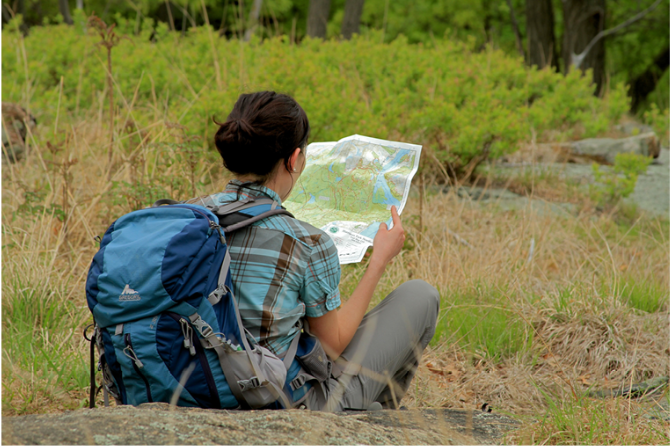
Map - Know where you are and where you are going. Many of our hiking areas feature interconnecting network of trails. Use a waterproof/tear-resistant Tyvek Trail Conference map if available or enclose your map in a Ziplock plastic bag. If you have a mobile device, download Avenza’s free PDF Maps app and grab some GPS-enhanced Trail Conference maps (a backup Tyvek or paper version of the map is good to have just in case your batteries die or you don't have service). Check out some map-reading basics here.
Food - Snacks/lunch will keep you going as you burn energy walking or climbing. Nuts, seeds, and chocolate are favorites on the trail.
Sunscreen and insect repellent
Rain Gear and Extra Clothing - Rain happens. So does cold. Be prepared for changing weather. Avoid cotton--it traps water against your skin and is slow to dry. If you are wearing wet cotton and must return to your starting point, you risk getting chills that may lead to a dangerous hypothermia. Choose synthetic shirts, sweaters and/or vests and dress in layers for easy on and off.
Compass - A simple compass is all you need to orient you and your map to magnetic north.
Light - A flashlight or small, lightweight headlamp will be welcome gear if you find yourself still on the trail when darkness falls. Check the batteries before you start out and have extras in your pack.
First Aid Kit - Keep it simple, compact, and weatherproof. Know how to use the basic components.
Firestarter and Matches - In an emergency, you may need to keep yourself or someone else warm until help arrives. A firestarter (this could be as simple as leftover birthday candles that are kept inside a waterproof container) and matches (again, make sure to keep them in a waterproof container) could save a life.
Knife or Multi-tool - You may need to cut a piece of moleskin to put over a blister, repair a piece of broken equipment, or solve some other unexpected problem.
Emergency Numbers - Know the emergency numbers for the area you're going to and realize that in many locations--especially mountainous ones, your phone will not get reception.
Common Sense - Pay attention to your environment, your energy, and the condition of your companions. Has the weather turned rainy? Is daylight fading? Did you drink all your water? Did your companion fail to bring rain gear? Are you getting tired? Keep in mind that until you turn around you are (typically) only half-way to completing your hike--you must still get back to where you started from! (Exceptions are loop hikes.)
Check the weather forecast before you head out. Know the rules and regulations of the area.
The Leave No Trace Seven Principles
Plan Ahead and Prepare
- Know the regulations and special concerns for the area you'll visit.
- Prepare for extreme weather, hazards, and emergencies.
- Schedule your trip to avoid times of high use.
- Visit in small groups when possible. Consider splitting larger groups into smaller groups.
- Repackage food to minimize waste.
- Use a map and compass to eliminate the use of marking paint, rock cairns or flagging.
Travel and Camp on Durable Surfaces
- Durable surfaces include established trails and campsites, rock, gravel, dry grasses or snow.
- Protect riparian areas by camping at least 200 feet from lakes and streams.
- Good campsites are found, not made. Altering a site is not necessary.
- In popular areas:
- Concentrate use on existing trails and campsites.
- Walk single file in the middle of the trail, even when wet or muddy.
- Keep campsites small. Focus activity in areas where vegetation is absent.
- In pristine areas:
- Disperse use to prevent the creation of campsites and trails.
- Avoid places where impacts are just beginning.
- Pack it in, pack it out. Inspect your campsite and rest areas for trash or spilled foods. Pack out all trash, leftover food and litter.
- Deposit solid human waste in catholes dug 6 to 8 inches deep, at least 200 feet from water, camp and trails. Cover and disguise the cathole when finished.
- Pack out toilet paper and hygiene products.
- To wash yourself or your dishes, carry water 200 feet away from streams or lakes and use small amounts of biodegradable soap. Scatter strained dishwater.
- Preserve the past: examine, but do not touch cultural or historic structures and artifacts.
- Leave rocks, plants and other natural objects as you find them.
- Avoid introducing or transporting non-native species.
- Do not build structures, furniture, or dig trenches.
- Campfires can cause lasting impacts to the backcountry. Use a lightweight stove for cooking and enjoy a candle lantern for light.
- Where fires are permitted, use established fire rings, fire pans, or mound fires.
- Keep fires small. Only use sticks from the ground that can be broken by hand.
- Burn all wood and coals to ash, put out campfires completely, then scatter cool ashes.
- Observe wildlife from a distance. Do not follow or approach them.
- Never feed animals. Feeding wildlife damages their health, alters natural behaviors, and exposes them to predators and other dangers.
- Protect wildlife and your food by storing rations and trash securely.
- Control pets at all times, or leave them at home.
- Avoid wildlife during sensitive times: mating, nesting, raising young, or winter.
Be Considerate of Other Visitors
- Respect other visitors and protect the quality of their experience.
- Be courteous. Yield to other users on the trail.
- Step to the downhill side of the trail when encountering pack stock.
- Take breaks and camp away from trails and other visitors.
- Let nature's sounds prevail. Avoid loud voices and noises.
The Trail Conference is a 2015 Leave No Trace partner.
(c) Leave No Trace Center for Outdoor Ethics: www.LNT.org.
Directions to Trailhead :
Take the Palisades Interstate Parkway to its northern end at the Bear Mountain Circle. Continue north on U.S. Route 9W for 8.1 miles to a parking area on the right at a sharp bend in the road. (This is the second parking area along Route 9W in Storm King State Park, but the only one which is designated by a blue “Parking Area” sign; it has a yellow-on-blue historical marker entitled “Freedom Road” and an adjacent marker commemorating the completion of the Storm King By-Pass Highway.)
TRAIN TRANSPORT :
Not availableBUS TRANSPORT :
Not availableShare Your Experience
SUPPORT
 Support the trails with a donation!
Trail Conference volunteers maintain trails in this hike.
Trip Reports
rate experience August 29, 2018
Challenging hike with terrific views
This is a very challenging hike with many great views of the Hudson River, the Central Valley, and NYC on a clear day. Trails are well marked. Definitely a hike worth checking out!
March 22, 2017
Awesome views!
Did this hike on the first day of Spring, however it was a week after a major snowstorm and it was more like a midwinter hike. The previous postings all attest to the tough ascent at the start. It was definitely hard, made more so by the 2 feet of snow. Still, taking one's time and using trekking poles made it enjoyable. The views from the two summits were a great reward for the work. Total time with stops for pics, etc.: 2 hours, 10 minutes.
August 28, 2016
Very nice
<p>Did this yesterday. Enoyable day out. I say people with dogs, baby carrier on the back, kids all make the trip. Think it'll be taxing for the kids/dogs...but for adults (even out of shape ones) it should be manageable. </p>
<p> </p>
<p>Identifying the parking lot may be a bit of a problem, but after that it's all simple. </p>
<p> </p>
<p>Follow the Orange Trail. The starting 15-20 mins is the tough part and has a bit of ascends and rock scrambling. Nothing really difficult though. Near the end of Orange trail you reach woods and safe from direct sunlight rest of the trip. </p>
<p>There are 2 overlooks, the first one you see is the smaller one (and most poeple incl us thought that was it) but 5 mins later you reach a ledge with a much bigger view. </p>
<p> </p>
<p>Continue on forwards through the Blue/Yellow trail and it leads to White Trail. Continue on the whites and you reach the parking lot again.</p>
<p> </p>
<p>Took us about 3.5 hrs at a very relaxed pace. </p>